As the hurricane becomes a category 1 tropical storm, there are still dangers that people need to know to avoid the most difficult day of the state of emergency.
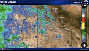
Isolated showers will continue early this morning across south-central Arizona. Further west, heavier rain is expected to develop later this morning across portions of southeastern California.
Rumorosa was closed to the dangers of flooding and lack of visibility.
Governor Gavin Newsom proclaimed a state of emergency for much of Southern California to support Hurricane Hilary response and recovery efforts as the state continues mobilizing and coordinating resources ahead of the storm’s forecasted impacts starting today.
At the Governor’s direction, there are currently more than 7,500 boots on the ground deployed to help local communities protect Californians from the impacts of Hurricane Hilary.
The Governor signed the emergency proclamation in San Diego while visiting with California National Guard troops. Also today, the Governor met with first responders and local officials, including San Diego Mayor Todd Gloria. He also was in touch with federal officials, including the White House.
What Governor Newsom said: “California has thousands of people on the ground working hand-in-hand with federal and local personnel to support communities in Hurricane Hilary’s path with resources, equipment and expertise. We’re mobilizing all of government as we prepare and respond to this unprecedented storm.”
With Governor Newsom issuing a State of Emergency and the devastation expected from Hurricane Hilary in the desert and under-resourced communities, Congressman Raul Ruiz urged President Biden to declare a Federal State of Emergency for Southern California and to expedite resources to assist in disaster mitigation, rescue, and rehabilitation.
“I will continue to advocate for the safety of the people I serve and work with local, state and federal agencies to facilitate needed resources,” Ruiz said.
Baja California Governor Marina Del Pilar said that there are risks of deadly flooding and asked everyone to remain safe as the storm passes.
“Let’s not let our guard down and follow all safety recommendations,” the governor said.
As Hurricane Hilary continues to affect our roads and infrastructure, the Imperial County Department of Public Works has established an interactive road closure map. This map provides real-time information to help residents navigate safe routes. Access the map on their main website:
https://publicworks.imperialcounty.org/
or directly via the following link: https://imperialcounty.maps.arcgis.com/apps/webappviewer/index.html?id=e44d2cef65b142f5a2ed11f2534a4285
In addition, the County Executive Office has established an interactive map displaying flood hazard areas, based on FEMA Flood Zones, to help travelers and residents be aware of areas with the highest risk of flooding. This map also displays road closures and can be accessed at the following link:
https://www.arcgis.com/apps/instant/basic/index.html?appid=fb4d603641bf4623abc0c8a0747a5adb


