Mexicali Launches Digital Platform to Track Urban Growth
Share your love
 -Editorial
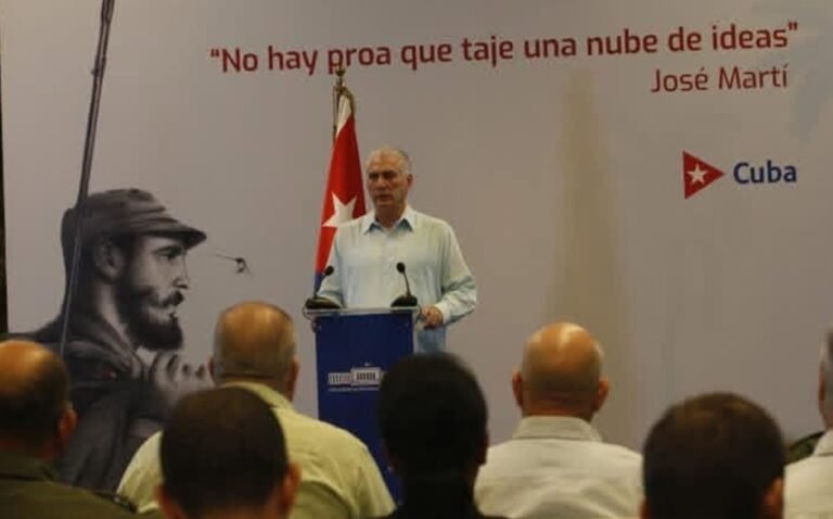
Mexicali Mayor Norma Bustamante joined city and education officials for a press conference on Nov. 26, presenting the new urban development initiative.
Carlos Gandara Woongg, a professor at the Autonomous University of Baja California (UABC), unveiled a new digital platform to visualize and analyze Mexicali’s urban development, part of the city’s broader initiative, Proyecto Mexicali del Futuro. The platform, named Ciudad Borde, seeks to provide residents, officials, and planners with a comprehensive understanding of the city’s evolution and challenges.
“This is a tool to study and make visible the evolution of Mexicali, especially the loss of urban density in the city’s downtown over the decades,” Gandara said. “By making the invisible visible, we empower citizens to understand their city and participate in better decision-making.”
Gandara emphasized that the platform is designed not only for experts but for the general public. It compiles verified data from the city government, universities, and civil society organizations, making urban trends, risks, and opportunities accessible to everyone.
“The city has grown for 120 years, influenced by factors such as the railroad, drainage systems, and historical population movements,” he said. “Ciudad Borde helps people see how these elements shaped our urban layout and why certain problems, like population loss in the central districts, have persisted.”
The platform organizes information into three key stages: the past, to understand historical development; the present, to assess current conditions; and a vision for the future, highlighting opportunities for revitalization and sustainable growth. Gandara noted that the city center, particularly Plaza Cachanilla, has faced decades of depopulation, and understanding these historical trends is critical to planning recovery and revitalization strategies.
“By understanding the factors that have shaped our city—from the cotton boom to migration spurred by the railroad—we can make informed decisions about urban planning, housing, and public services,” Gandara said. “It fosters collaboration between authorities and residents and encourages a vision of Mexicali as a city that is inclusive, transparent, and forward-looking.”
The initiative represents a collaboration between UABC, the Mexicali municipal government, Tecnológico de Monterrey, and several civil associations. Gandara emphasized that the platform is grounded in verified data, not conjecture, ensuring that future urban policies are informed by accurate information.
“Ciudad Borde is more than a map—it is a tool for civic engagement,” he said. “When citizens have access to information, they can participate more effectively in shaping their city’s future. This platform allows us to see risks and opportunities clearly, enabling smarter decisions for both governance and daily life.”
Gandara added that while the tool highlights historical trends, it is ultimately intended to guide practical, forward-looking decisions that benefit all residents.
“This initiative reflects a commitment to transparency, collaboration, and sustainable urban development,” he said. “It is a first step toward building a more resilient and informed Mexicali, where the community knows to participate in shaping its own future.”
Roberto Ponce López, a professor at Tecnológico de Monterrey, explained that while isolated maps exist showing social or environmental indicators, this tool links them to reveal underlying patterns.
“For example, urban heat islands, population density, and employment distribution are all interconnected,” he said. “Mexicali’s dispersed urban model has consequences on environmental conditions, social equity, and quality of life.”
Ponce López highlighted trends over the past two decades, noting that 42% of the urban center has lost population while peripheral areas grew faster than population density. “We’ve had 28,000 people leave the central three-kilometer radius, creating urban voids and infrastructure mismatches,” he said.
The platform also visualizes accessibility to schools, hospitals, parks, and public services, revealing disparities where population growth has outpaced available amenities. “The areas gaining population often have better access to public services, while central areas losing residents face equipment deficits,” he said.
In the environmental layer, the platform maps air quality, vegetation, and urban heat, integrating data from civil organizations like Redspira and the Sonoran Institute. Users can interact with Google Street View imagery processed with computer vision to explore urban gaps visually.
Looking ahead, Ciudad Borde offers a future-oriented scenario modeling for 2040, projecting population growth and opportunities to increase green space from 2 m² per person to 7 m² per person, and redevelop central corridors with medium-density construction and integrated public transport.
“We also interviewed 1,400 residents using WhatsApp voice surveys to understand their priorities,” Ponce López said. “Citizens want more green spaces, shade, and efficient public transport, and the platform allows us to visualize and incorporate their voices into planning.”
The project is a collaboration between Tecnológico de Monterrey, UABC, municipal authorities, and civil society, representing a model for combining technical rigor with public engagement.